
Unlocking Subsurface Value with GeoSoftware Professional Services
Read More

Exploring less-studied basins and frontier areas presents a unique set of challenges for geoscientists. With limited well control and incomplete geological understanding, identifying prospective intervals and understanding subsurface variability, even with large volumes of seismic data, can be difficult. Without sufficient geological context, seismic anomalies may be challenging to interpret, making early-stage prospect evaluation more uncertain.
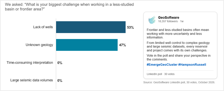
In a recent GeoSoftware LinkedIn poll asking about the biggest challenges when working in less-studied basins or frontier areas, 53% of respondents identified a lack of wells as their primary challenge, while 47% pointed to unknown geology. These results highlight a common theme across E&P workflows: the need to extract more geological information from seismic attributes and well data that’s already available.
HampsonRussell Emerge GeoCluster addresses these challenges by combining machine learning clustering and classification to transform seismic attribute volumes into geologically meaningful facies patterns. By identifying natural groupings in seismic data and connecting those patterns to available well information, geoscientists can gain valuable geological insight earlier in the evaluation process.
Seismic data contains valuable information about subsurface formations, but interpreting that information in areas with limited well control is not always straightforward. A seismic anomaly may indicate a change in lithology, fluid properties, or another geological feature. Without sufficient calibration, understanding what the anomaly represents can be difficult.
Emerge GeoCluster introduces a workflow that goes beyond identifying generic seismic anomalies. It groups samples with similar seismic attribute responses into natural geological domains, then uses available well information to associate those clusters with lithology and facies.
Because the workflow runs inside Emerge, co-developed by Mobil Research and HampsonRussell as the first machine learning program that was available to geoscientists, additional attribute volumes are computed on the fly from the input seismic, with no pre-processing or exporting needed. You can optionally add other inputs as they become available, such as a preliminary inversion, AVO attributes, Amplitude versus Frequency (AVF) or spectral decomposition volumes. An attribute selection process using multi-linear regression or principal component analysis (PCA) helps identify the attributes most relevant to the geological properties being investigated.
From there, geoscientists can apply unsupervised clustering methods such as Self-Organizing Maps (SOM), K-means, or Gaussian Mixture Models (GMM) to identify groups of samples with similar characteristics. The clusters can then be classified using well logs through Bayesian classification mapping or the Probabilistic Neural Network (PNN).
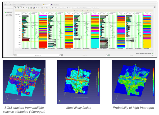
The result is a predicted facies volume accompanied by probability information that helps geoscientists understand both the likely geological distribution and the uncertainty associated with their interpretation.
Importantly, the clustering process does not require dense well control. While available wells remain essential for tying clusters to geological facies, the workflow can begin identifying patterns across seismic volumes even when well information is limited.
One of the key advantages of this technology is the ability to begin evaluating geological patterns before a detailed Quantitative Interpretation (QI) workflow is complete.
Preliminary inversion and spectral attributes are often available during the early stages of a project. These volumes can provide the initial inputs for clustering while more advanced analyses, such as model-based inversion, geostatistical inversion, AVO interpretation, and rock physics modeling, are still being developed.
This creates an opportunity to bring geological context into prospect evaluation sooner.
Rather than waiting until later project stages to generate detailed facies and property volumes, geoscientists can begin examining geological variability, identifying potential target intervals, and understanding how different areas of a survey compare. This earlier insight supports more informed screening decisions and helps focus additional interpretation efforts on the opportunities with the greatest potential.
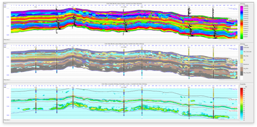
Results from Emerge GeoCluster workflow: Cluster results (top), Bayesian Classification Mapping Results (Middle); Probability Results (Bottom)
For exploration teams working in frontier basins or less-studied areas, the ability to extract meaningful geological information from existing datasets can make a significant difference.
HampsonRussell Emerge GeoCluster helps geoscientists:
When working in areas with limited well data and poorly understood geology, geoscientists need ways to make the most of the information available to them. Seismic attributes provide an important starting point, but connecting those attributes to meaningful geological patterns is essential for effective prospect screening.
HampsonRussell Emerge GeoCluster brings machine learning clustering and classification into the Emerge workflow, helping geoscientists move from seismic attribute analysis toward geological understanding earlier in the project. By identifying natural patterns, mapping them to available well information, and generating facies probability volumes, teams can better understand subsurface variability and focus their efforts on the opportunities worth investigating further.
Watch the on-demand webinar recording, From Seismic Attributes to Geological Insight Faster with Emerge GeoCluster, presented by Ruth Kurian, Technical Product Owner at HampsonRussell.


